Operating indicators, linked cases and evidence-led collection priorities.
Version recorded 15 Oct 2026 · 19:58 UTC. Related source records show their available archive versions.
Links use the site’s current access permissions.
DOCUMENTED CASUALTYRECENT EVIDENCE REVIEWTrend · NOT ESTABLISHED
PARTIAL COLLECTIONSources checked 15 Oct 2026 · 19:58 UTCEvidence review 15 Oct 2026 · 10:25 UTCLatest source evidence 14 Oct 2026 · 20:01 UTC
A confirmed casualty is documented in this theatre. The label describes local exposure, not a corridor-wide threat score.
Reports to follow up · 7D
13
Accounts, not unique incidents
Reviewed products · 7D
4
Case-level analytical updates
Evidence gaps
2 / 4
Operating dimensions to verify
HISTORICAL ASSESSMENT
The loss of one 2,824-TEU feeder does not create a system-wide capacity shortage. It does confirm that Hormuz risk now includes direct physical loss, schedule disruption, salvage exposure and higher insurance uncertainty within the regional feeder network. The strategic consequence is therefore larger than the capacity of one hull, but it should not be overstated as a general breakdown of Gulf container connectivity. MSCIO ALERT 136/26 is best treated as a new, vessel-anonymous incident at 19:20 UTC on 10 October, not as an update to the 9 October Al Jazeera/Gem No.2 case. UKMTO WARNING 162-26 reproduces the same time, direction, impact side, fire and crew status from the master, so the two notices describe one reporting chain rather than two independently confirmed attacks. The safe-crew report reduces the immediate casualty concern, but the unresolved fire, damage, propulsion and pollution status leave the tanker’s operational outcome open. MSCIO ALERT 137/26 is best treated provisionally as a later incident report at 12:00 UTC on 11 October, distinct from ALERT 136/26 at 19:20 UTC on 10 October. UKMTO WARNING 164-26 reproduces the later time, outbound direction, port-side impact, damage, crew-safe status and no reported environmental impact from a company security officer, so MSCIO and UKMTO represent one reporting chain rather than independent confirmation. The record extends the observed hazard window for outbound tankers, but it does not identify the vessel, establish attribution, confirm its ability to proceed or demonstrate closure of the Strait. GFS PRIDE adds direct container-feeder exposure and a reported wreck/containers hazard. Regional connectivity effects remain unmeasured; attribution, environmental condition and casualty-specific satellite linkage remain open.
Confidence belongs to individual claims and cases below. No separately reviewed theatre-wide threat rating or comparable trend baseline is attached; event confidence is not inherited by the whole region.
No comparable, independently reviewed theatre baseline establishes improving or deteriorating conditions. A new source report or review date alone does not demonstrate a trend.
EVIDENCE → IMPLICATION → NEXT DECISION
Operating indicators
Evidence states, not live sensor readings or a regional risk score. Each indicator states what would change the judgment.
Security & vessel condition
DOCUMENTED
A confirmed casualty establishes physical exposure at vessel level. This does not establish attack attribution, corridor closure or the condition of every transit.
Collect · A dated authority or operator update matching vessel identity and event time; reconcile related notices and follow-up.
Revise when · Confirmed damage, assistance, release or a formal navigation restriction changes the vessel-level assessment.
Navigation & recovery
REPORTED
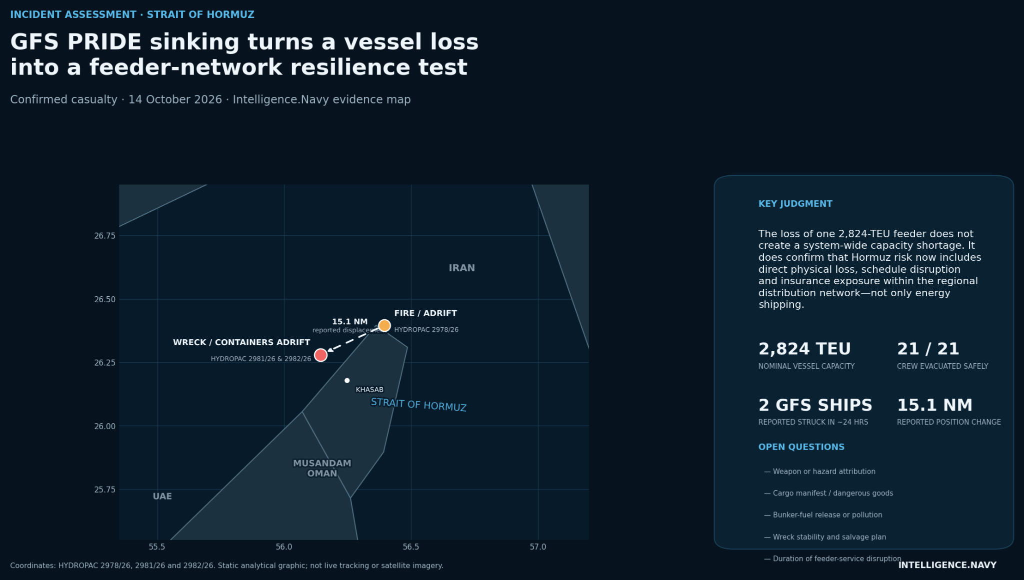
HYDROPAC 2981/26 and 2982/26 report the wreck and containers adrift at 26°16.80′ N, 56°08.60′ E. The warning position is not a surveyed debris boundary or proof of clearance.
Collect · Check the latest warning revision or cancellation, wreck stability and the authority responsible for container recovery.
Revise when · A revised hazard position, warning cancellation or verified recovery outcome changes the navigation picture.
Trade & feeder connectivity
GAP
Loss of a feeder hull creates direct schedule, salvage and cargo exposure. The record does not quantify network-wide capacity loss, port closure or regional service disruption.
The loss of one 2,824-TEU feeder does not create a system-wide capacity shortage. It does confirm that Hormuz risk now includes direct physical loss, schedule disruption, salvage exposure and higher insurance uncertainty within the regional feeder network. The strategic consequence is therefore larger than the capacity of one hull, but it should not be overstated as a general breakdown of Gulf container connectivity.
MSCIO ALERT 136/26 is best treated as a new, vessel-anonymous incident at 19:20 UTC on 10 October, not as an update to the 9 October Al Jazeera/Gem No.2 case. UKMTO WARNING 162-26 reproduces the same time, direction, impact side, fire and crew status from the master, so the two notices describe one reporting chain rather than two independently confirmed attacks. The safe-crew report reduces the immediate casualty concern, but the unresolved fire, damage, propulsion and pollution status leave the tanker’s operational outcome open.
MSCIO ALERT 137/26 is best treated provisionally as a later incident report at 12:00 UTC on 11 October, distinct from ALERT 136/26 at 19:20 UTC on 10 October. UKMTO WARNING 164-26 reproduces the later time, outbound direction, port-side impact, damage, crew-safe status and no reported environmental impact from a company security officer, so MSCIO and UKMTO represent one reporting chain rather than independent confirmation. The record extends the observed hazard window for outbound tankers, but it does not identify the vessel, establish attribution, confirm its ability to proceed or demonstrate closure of the Strait.
GFS PRIDE adds direct container-feeder exposure and a reported wreck/containers hazard. Regional connectivity effects remain unmeasured; attribution, environmental condition and casualty-specific satellite linkage remain open.
STATIC EVIDENCE MAP
Editorial geospatial reconstruction based on reported navigation-warning positions. The connecting line represents the approximate displacement between two reported positions, not a continuously observed vessel track.
The loss of one 2,824-TEU feeder does not create a system-wide capacity shortage. It does confirm that Hormuz risk now includes direct physical loss, schedule disruption, salvage exposure and higher insurance uncertainty within the regional feeder network. The strategic consequence is therefore larger than the capacity of one hull, but it should not be overstated as a general breakdown of Gulf container connectivity. MSCIO ALERT 136/26 is best treated as a new, vessel-anonymous incident at 19:20 UTC on 10 October, not as an update to the 9 October Al Jazeera/Gem No.2 case. UKMTO WARNING 162-26 reproduces the same time, direction, impact side, fire and crew status from the master, so the two notices describe one reporting chain rather than two independently confirmed attacks. The safe-crew report reduces the immediate casualty concern, but the unresolved fire, damage, propulsion and pollution status leave the tanker’s operational outcome open. MSCIO ALERT 137/26 is best treated provisionally as a later incident report at 12:00 UTC on 11 October, distinct from ALERT 136/26 at 19:20 UTC on 10 October. UKMTO WARNING 164-26 reproduces the later time, outbound direction, port-side impact, damage, crew-safe status and no reported environmental impact from a company security officer, so MSCIO and UKMTO represent one reporting chain rather than independent confirmation. The record extends the observed hazard window for outbound tankers, but it does not identify the vessel, establish attribution, confirm its ability to proceed or demonstrate closure of the Strait. GFS PRIDE adds direct container-feeder exposure and a reported wreck/containers hazard. Regional connectivity effects remain unmeasured; attribution, environmental condition and casualty-specific satellite linkage remain open.
What changed
GFS PRIDE sinking broadens the Hormuz threat from energy shipping to regional trade connectivity
Maritime operating picture
Source-reported encounters, local vessel condition and regional access are separate layers. 13 source accounts with open follow-up questions fall within the last seven days. They may concern the same event; missing follow-up does not establish that an incident remains active.
Musandam approaches The reported GFS PRIDE wreck position links this dossier with Hormuz; this is one casualty, not a second incident.
Gulf of Oman ports and approaches Access, response and container connections require dated operator or authority evidence.
Relevant actors
Omani maritime and environmental authorities Dated notices establish local restrictions and response responsibilities.
Navigation-warning services and ship operators Separate a reported hazard position from verified clearance or service continuity.
Environmental exposure
Pollution, bunker release, dangerous goods and container contents remain unconfirmed. Neither the editorial illustration nor the unverified satellite linkage establishes contamination.
Sanctions & insurance
No verified current premium, P&I change or sanctions-impact metric is attached. Vessel designation, insurance terms and operational effects require separate dated evidence.
Indicators & watch next
further attacks against container or feeder vessels;
service, schedule or routing changes announced by GFS or AD Ports Group;
temporary suspension or reduction of Hormuz feeder services;
changes in war-risk premiums for container and feeder shipping;
A new or cancelled navigation warning for the GFS PRIDE wreck and drifting containers.
A dated authority or salvor update on wreck stability and container recovery.
Cargo documentation and time-matched observations if pollution is suspected.
Trigger: a dated authority update or a verified operational change that alters the baseline. Unobserved indicators have no assigned direction or warning score.
Intelligence gaps
Precise incident time, damage mechanism, weapon type, launch point and attribution.
Whether either vessel or the GFS operator was deliberately selected.
Cargo manifest and dangerous-goods content.
Bunker-fuel quantities and any bunker-fuel release.
Environmental pollution: present condition, extent and any discharge remain unverified; retain the dated IMO no-pollution report.
Wreck depth, orientation and wreck stability.
Theatre-wide traffic, insurance and environmental coverage are incomplete. No direct HUMINT has been collected for this dossier.
Public readers use the existing hourly collection cycle and five-minute refresh while the main watch is open. Unavailable readers retain dated records.
Records are linked by named area, explicit theatre tag or reported position. Approximate positions remain labelled. Shared geography does not duplicate the article or establish a shared incident.
Reviewed case judgments feed the dossier. Event confidence, editorial priority and a theatre-wide threat rating remain separate.
Changed evidence, corrections and analytical states enter the version history. A repeated source check does not become a new analytical review.
Open gaps guide the research queue. New substantive assessments follow the existing research stages and human publication approval.
Unavailable readers represented here: UKMTO. Retained records may predate the latest check.
Assessment versions & corrections
Changed analytical states are preserved from activation, up to the latest 60 versions. A collection check does not create a revision when the assessment is unchanged. Source-publication versions remain in the existing archive.
AI-assisted synthesis of dated case evidence. No separate human analyst sign-off or theatre-wide risk rating. Node and actor profiles explain strategic relevance; they do not disclose live asset status.
Gulf of Oman / Musandam theatre dossier | Intelligence.Navy